|
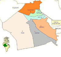  The Governorate of Kebili is located in the South-West of Tunisia . It is bordered by Gafsa, Tozeur and Gabes to the North, Medenine and Tataouine to the East, and Algeria to the South. The Governorate of Kebili is located in the South-West of Tunisia . It is bordered by Gafsa, Tozeur and Gabes to the North, Medenine and Tataouine to the East, and Algeria to the South.
It covers 22,784 km2 and has 05 delegations, 05 municipalities, and 07 rural councils.
|
Indicator |
Governorate |
Sector |
|
Population |
155300 |
1593800 |
|
Active Population |
47406 |
482632 |
|
Rate of the urban population |
53,6% |
70,8% |
|
Global rate of providing drinkable water |
99,9% |
99,6% |
|
Rate of providing drinkable water in rural areas |
99,8% |
98,5% |
|
Global rate of connecting families with electricity |
99,7% |
99,5% |
|
Rate of connecting rural families with electricity |
99,5% |
98,9% |
|
Rate of connecting inhabitants with the sanitary system |
59,9% |
59,4% |
|
Nb of inhabitants per doctor |
1538 |
1261 |
|
Nb of High Institutes |
1 |
31 |
|
Nb of hospital beds per 100.000 inhabitants |
130 |
170 |
|
Hospitals and private clinics |
5 |
43 |
|
Number of phone lines /100 inh |
8,3 |
9,2 |
|
Nb of subscribers in the home phone system |
12900 |
146000 |
|
Nb of subscribers in the mobile phone |
213300 |
2396700 |
|
Rate of families using Internet |
11,5% |
18,9% |
|
Rate of families having home computers |
16,8% |
14,5% |
|
Nb of primary schools |
79 |
848 |
|
Nb of elementary and secondary schools |
35 |
306 |
|
Centres of professional formation |
10 |
177
|
 Data year : 2012 Data year : 2012 |
The main characteristics of the Governorate :
Natural resources : Important water resources, mobilized exploited in the creation of irrigated areas; the rehabilitation of the oases and the production of first fruits, using geothermal waters.
Infrastructures : A road network with 1266 km long; a rate of providing drinkable water, reaching 99,9%; a rate of providing electricity, reaching 99,7%.
An economy based on the production of dates (Deglet Nour), livestock raising, field agriculture, and a growing touristic activity. |
")


